


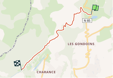
Canal du Drac - depuis le réservoir des Manes jusqu'à l'écluse de l'Oeuf

frizou83
Gebruiker

Lengte
5,2 km

Max. hoogte
1158 m

Positief hoogteverschil
66 m
Km-Effort
6,1 km

Min. hoogte
1133 m

Negatief hoogteverschil
67 m
Boucle
Neen
Datum van aanmaak :
2025-06-08 14:03:55.391
Laatste wijziging :
2025-06-08 14:05:52.274
1h22
Moeilijkheid : Medium

Gratisgps-wandelapplicatie
 SityTrail
IGN / Geografische instituten
SityTrail Plus
De wereld gaat voor u open
Over ons
Tocht Stappen van 5,2 km beschikbaar op Provence-Alpes-Côte d'Azur, Hautes-Alpes, Gap. Deze tocht wordt voorgesteld door frizou83.
Plaatsbepaling
Land:
France
Regio :
Provence-Alpes-Côte d'Azur
Departement/Provincie :
Hautes-Alpes
Gemeente :
Gap
Locatie:
Gap
Vertrek:(Dec)
Vertrek:(UTM)
268526 ; 4942431 (32T) N.
Opmerkingen