


Rozenn

PatriceCocuaud
Gebruiker
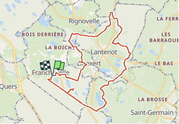

Lengte
21 km

Max. hoogte
370 m

Positief hoogteverschil
291 m
Km-Effort
24 km

Min. hoogte
296 m

Negatief hoogteverschil
293 m
Boucle
Ja
Datum van aanmaak :
2025-06-12 07:48:30.222
Laatste wijziging :
2025-06-12 10:09:57.432
2h21
Moeilijkheid : Gemakkelijk

Gratisgps-wandelapplicatie
 SityTrail
IGN / Geografische instituten
SityTrail Plus
De wereld gaat voor u open
Over ons
Tocht Mountainbike van 21 km beschikbaar op Bourgondië-Franche-Comté, Haute-Saône, Franchevelle. Deze tocht wordt voorgesteld door PatriceCocuaud.
Plaatsbepaling
Land:
France
Regio :
Bourgondië-Franche-Comté
Departement/Provincie :
Haute-Saône
Gemeente :
Franchevelle
Locatie:
Unknown
Vertrek:(Dec)
Vertrek:(UTM)
309552 ; 5290287 (32T) N.
Opmerkingen