


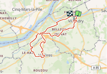
Villandry - Vallères - 16.3km 145m 4h30 (1h) - 2025 06 12

Orcal37
Gebruiker GUIDE

Lengte
16,3 km

Max. hoogte
87 m

Positief hoogteverschil
145 m
Km-Effort
18,3 km

Min. hoogte
37 m

Negatief hoogteverschil
145 m
Boucle
Ja
Datum van aanmaak :
2025-06-12 09:34:19.752
Laatste wijziging :
2025-06-13 07:22:22.758
4h30
Moeilijkheid : Gemakkelijk

Gratisgps-wandelapplicatie
 SityTrail
IGN / Geografische instituten
SityTrail Plus
De wereld gaat voor u open
Over ons
Tocht Stappen van 16,3 km beschikbaar op Centre-Val de Loire, Indre-et-Loire, Villandry. Deze tocht wordt voorgesteld door Orcal37.
Beschrijving
Villandry - Vallères - 16.3km 145m 4h30 (1h) - 2025 06 12
Foto's
 - 2025 06 12 - Photo 1")
 - 2025 06 12 - Photo 2")
 - 2025 06 12 - Photo 3")
 - 2025 06 12 - Photo 4")
 - 2025 06 12 - Photo 5")
 - 2025 06 12 - Photo 6")
 - 2025 06 12 - Photo 7")
 - 2025 06 12 - Photo 8")
Plaatsbepaling
Land:
France
Regio :
Centre-Val de Loire
Departement/Provincie :
Indre-et-Loire
Gemeente :
Villandry
Locatie:
Unknown
Vertrek:(Dec)
Vertrek:(UTM)
311778 ; 5245916 (31T) N.
Opmerkingen