


tresque

mthomas30
Gebruiker
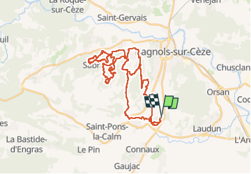

Lengte
44 km

Max. hoogte
290 m

Positief hoogteverschil
890 m
Km-Effort
56 km

Min. hoogte
65 m

Negatief hoogteverschil
891 m
Boucle
Ja
Datum van aanmaak :
2025-06-15 05:33:11.594
Laatste wijziging :
2025-06-15 09:36:33.108
3h42
Moeilijkheid : Moeilijk

Gratisgps-wandelapplicatie
 SityTrail
IGN / Geografische instituten
SityTrail Plus
De wereld gaat voor u open
Over ons
Tocht Mountainbike van 44 km beschikbaar op Occitanië, Gard, Tresques. Deze tocht wordt voorgesteld door mthomas30.
Plaatsbepaling
Land:
France
Regio :
Occitanië
Departement/Provincie :
Gard
Gemeente :
Tresques
Locatie:
Unknown
Vertrek:(Dec)
Vertrek:(UTM)
628986 ; 4885732 (31T) N.
Opmerkingen