


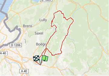
Vélo(74) - Viuz - Plaine-Joux - Col de Jambaz- Col du Feu - Col de Cou - Col du Perret - Viuz

HG74250
Gebruiker

Lengte
66 km

Max. hoogte
1222 m

Positief hoogteverschil
2133 m
Km-Effort
95 km

Min. hoogte
599 m

Negatief hoogteverschil
2132 m
Boucle
Ja
Datum van aanmaak :
2025-07-03 19:56:02.183
Laatste wijziging :
2025-07-03 20:05:25.43
5h44
Moeilijkheid : Zeer moeilijk

Gratisgps-wandelapplicatie
 SityTrail
IGN / Geografische instituten
SityTrail Plus
De wereld gaat voor u open
Over ons
Tocht Wegfiets van 66 km beschikbaar op Auvergne-Rhône-Alpes, Haute-Savoie, Viuz-en-Sallaz. Deze tocht wordt voorgesteld door HG74250.
Plaatsbepaling
Land:
France
Regio :
Auvergne-Rhône-Alpes
Departement/Provincie :
Haute-Savoie
Gemeente :
Viuz-en-Sallaz
Locatie:
Unknown
Vertrek:(Dec)
Vertrek:(UTM)
299488 ; 5113127 (32T) N.
Opmerkingen