


Bisous J 1

jacques.seux
Gebruiker
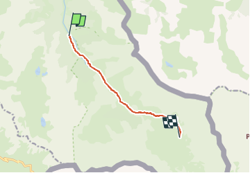

Lengte
7,2 km

Max. hoogte
2471 m

Positief hoogteverschil
676 m
Km-Effort
14 km

Min. hoogte
1796 m

Negatief hoogteverschil
10 m
Boucle
Neen
Datum van aanmaak :
2025-07-04 12:29:51.0
Laatste wijziging :
2025-07-04 12:29:52.52

Gratisgps-wandelapplicatie
 SityTrail
IGN / Geografische instituten
SityTrail Plus
De wereld gaat voor u open
Over ons
Tocht van 7,2 km beschikbaar op Provence-Alpes-Côte d'Azur, Hautes-Alpes, Abriès-Ristolas. Deze tocht wordt voorgesteld door jacques.seux.
Plaatsbepaling
Land:
France
Regio :
Provence-Alpes-Côte d'Azur
Departement/Provincie :
Hautes-Alpes
Gemeente :
Abriès-Ristolas
Locatie:
Ristolas
Vertrek:(Dec)
Vertrek:(UTM)
341397 ; 4955590 (32T) N.
Opmerkingen