


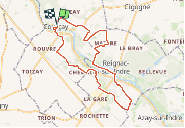
Courçay - PRs Reignac-sur-Indre GR46 - 18.3km 185m 5h25 (1h05) - 2025 07 04

Orcal37
Gebruiker GUIDE

Lengte
18,3 km

Max. hoogte
96 m

Positief hoogteverschil
184 m
Km-Effort
21 km

Min. hoogte
58 m

Negatief hoogteverschil
186 m
Boucle
Ja
Datum van aanmaak :
2025-07-04 08:34:18.725
Laatste wijziging :
2025-07-06 10:04:18.508
5h25
Moeilijkheid : Medium

Gratisgps-wandelapplicatie
 SityTrail
IGN / Geografische instituten
SityTrail Plus
De wereld gaat voor u open
Over ons
Tocht Stappen van 18,3 km beschikbaar op Centre-Val de Loire, Indre-et-Loire, Courçay. Deze tocht wordt voorgesteld door Orcal37.
Beschrijving
Courçay - via PRs - Reignac-sur-Indre - via GR46 - 18.3km 185m 5h25 (1h05) - 2025 07 04
Foto's
 - 2025 07 04 - Photo 1")
 - 2025 07 04 - Photo 2")
 - 2025 07 04 - Photo 3")
 - 2025 07 04 - Photo 4")
 - 2025 07 04 - Photo 5")
 - 2025 07 04 - Photo 6")
 - 2025 07 04 - Photo 7")
 - 2025 07 04 - Photo 8")
 - 2025 07 04 - Photo 9")
 - 2025 07 04 - Photo 10")
 - 2025 07 04 - Photo 11")
 - 2025 07 04 - Photo 12")
 - 2025 07 04 - Photo 13")
 - 2025 07 04 - Photo 14")
Plaatsbepaling
Land:
France
Regio :
Centre-Val de Loire
Departement/Provincie :
Indre-et-Loire
Gemeente :
Courçay
Locatie:
Unknown
Vertrek:(Dec)
Vertrek:(UTM)
339379 ; 5235290 (31T) N.
Opmerkingen