


SityTrail - queyssac 2025

Gpoujade
Gebruiker
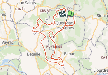

Lengte
24 km

Max. hoogte
335 m

Positief hoogteverschil
631 m
Km-Effort
33 km

Min. hoogte
128 m

Negatief hoogteverschil
631 m
Boucle
Ja
Datum van aanmaak :
2025-07-05 18:38:42.839
Laatste wijziging :
2025-07-05 18:39:13.491
2h15
Moeilijkheid : Moeilijk

Gratisgps-wandelapplicatie
 SityTrail
IGN / Geografische instituten
SityTrail Plus
De wereld gaat voor u open
Over ons
Tocht Mountainbike van 24 km beschikbaar op Nieuw-Aquitanië, Corrèze, Queyssac-les-Vignes. Deze tocht wordt voorgesteld door Gpoujade.
Plaatsbepaling
Land:
France
Regio :
Nieuw-Aquitanië
Departement/Provincie :
Corrèze
Gemeente :
Queyssac-les-Vignes
Locatie:
Unknown
Vertrek:(Dec)
Vertrek:(UTM)
403096 ; 4980380 (31T) N.
Opmerkingen