


2025-07-07_14h19m14_t314271646_boucle glacimont- chaudes

Pauline Muller
Gebruiker
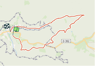

Lengte
9,3 km

Max. hoogte
672 m

Positief hoogteverschil
253 m
Km-Effort
12,8 km

Min. hoogte
433 m

Negatief hoogteverschil
294 m
Boucle
Ja
Datum van aanmaak :
2025-07-07 12:19:14.504
Laatste wijziging :
2025-07-07 12:19:15.856

Gratisgps-wandelapplicatie
 SityTrail
IGN / Geografische instituten
SityTrail Plus
De wereld gaat voor u open
Over ons
Tocht van 9,3 km beschikbaar op Grand Est, Vogezen, Raon-sur-Plaine. Deze tocht wordt voorgesteld door Pauline Muller.
Plaatsbepaling
Land:
France
Regio :
Grand Est
Departement/Provincie :
Vogezen
Gemeente :
Raon-sur-Plaine
Locatie:
Unknown
Vertrek:(Dec)
Vertrek:(UTM)
359660 ; 5374659 (32U) N.
Opmerkingen