


Koekelare - Torhout

FreddyTuerlinckx
Gebruiker
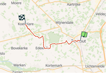

Lengte
14,4 km

Max. hoogte
44 m

Positief hoogteverschil
77 m
Km-Effort
15,4 km

Min. hoogte
12 m

Negatief hoogteverschil
81 m
Boucle
Neen
Datum van aanmaak :
2025-07-16 15:33:07.792
Laatste wijziging :
2025-07-29 07:20:21.865
3h30
Moeilijkheid : Gemakkelijk

Gratisgps-wandelapplicatie
 SityTrail
IGN / Geografische instituten
SityTrail Plus
De wereld gaat voor u open
Over ons
Tocht Te voet van 14,4 km beschikbaar op Vlaanderen, West-Vlaanderen, Torhout. Deze tocht wordt voorgesteld door FreddyTuerlinckx.
Beschrijving
Bus 55 van Torhout station tot Koekelare Dorp
Plaatsbepaling
Land:
Belgium
Regio :
Vlaanderen
Departement/Provincie :
West-Vlaanderen
Gemeente :
Torhout
Locatie:
Unknown
Vertrek:(Dec)
Vertrek:(UTM)
507386 ; 5657034 (31U) N.
Opmerkingen