


Forêt

Joefrey
Gebruiker
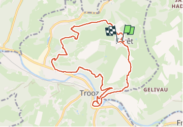

Lengte
9,3 km

Max. hoogte
258 m

Positief hoogteverschil
347 m
Km-Effort
13,9 km

Min. hoogte
92 m

Negatief hoogteverschil
349 m
Boucle
Ja
Datum van aanmaak :
2025-07-19 08:09:00.0
Laatste wijziging :
2025-07-19 10:17:54.887
2h08
Moeilijkheid : Onbekend

Gratisgps-wandelapplicatie
 SityTrail
IGN / Geografische instituten
SityTrail Plus
De wereld gaat voor u open
Over ons
Tocht Lopen van 9,3 km beschikbaar op Wallonië, Luik, Trooz. Deze tocht wordt voorgesteld door Joefrey.
Plaatsbepaling
Land:
Belgium
Regio :
Wallonië
Departement/Provincie :
Luik
Gemeente :
Trooz
Locatie:
Unknown
Vertrek:(Dec)
Vertrek:(UTM)
691102 ; 5607026 (31U) N.
Opmerkingen