


La Brousse/Sommet de Finiels/ Signal des Laubies

tyntyn
Gebruiker
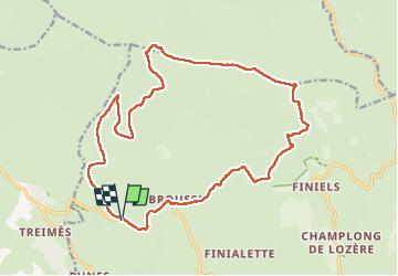

Lengte
21 km

Max. hoogte
1699 m

Positief hoogteverschil
579 m
Km-Effort
29 km

Min. hoogte
1201 m

Negatief hoogteverschil
579 m
Boucle
Ja
Datum van aanmaak :
2025-07-22 06:11:22.874
Laatste wijziging :
2025-07-24 13:21:06.929
7h30
Moeilijkheid : Moeilijk

Gratisgps-wandelapplicatie
 SityTrail
IGN / Geografische instituten
SityTrail Plus
De wereld gaat voor u open
Over ons
Tocht Stappen van 21 km beschikbaar op Occitanië, Lozère, Pont de Montvert - Sud Mont Lozère. Deze tocht wordt voorgesteld door tyntyn.
Foto's


Plaatsbepaling
Land:
France
Regio :
Occitanië
Departement/Provincie :
Lozère
Gemeente :
Pont de Montvert - Sud Mont Lozère
Locatie:
Fraissinet-de-Lozère
Vertrek:(Dec)
Vertrek:(UTM)
554605 ; 4916117 (31T) N.
Opmerkingen