


Trace Escot G3 Guy 250725

mitch1952
Gebruiker
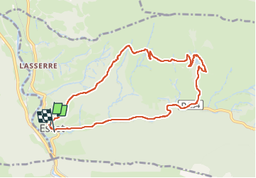

Lengte
10,7 km

Max. hoogte
734 m

Positief hoogteverschil
427 m
Km-Effort
16,4 km

Min. hoogte
327 m

Negatief hoogteverschil
439 m
Boucle
Ja
Datum van aanmaak :
2025-07-25 07:26:10.0
Laatste wijziging :
2025-07-25 13:30:57.656

Gratisgps-wandelapplicatie
 SityTrail
IGN / Geografische instituten
SityTrail Plus
De wereld gaat voor u open
Over ons
Tocht van 10,7 km beschikbaar op Nieuw-Aquitanië, Pyrénées-Atlantiques, Escot. Deze tocht wordt voorgesteld door mitch1952.
Plaatsbepaling
Land:
France
Regio :
Nieuw-Aquitanië
Departement/Provincie :
Pyrénées-Atlantiques
Gemeente :
Escot
Locatie:
Unknown
Vertrek:(Dec)
Vertrek:(UTM)
694782 ; 4772198 (30T) N.
Opmerkingen