


Sene

lm178
Gebruiker

Lengte
6,9 km

Max. hoogte
20 m

Positief hoogteverschil
44 m
Km-Effort
7,5 km

Min. hoogte
3 m

Negatief hoogteverschil
42 m
Boucle
Neen
Datum van aanmaak :
2025-07-18 12:56:43.064
Laatste wijziging :
2025-07-26 17:15:49.79
1h53
Moeilijkheid : Heel gemakkelijk

Gratisgps-wandelapplicatie
 SityTrail
IGN / Geografische instituten
SityTrail Plus
De wereld gaat voor u open
Over ons
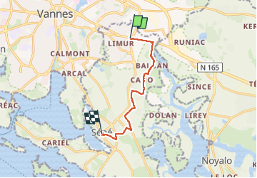
Tocht Stappen van 6,9 km beschikbaar op Bretagne, Morbihan, Séné. Deze tocht wordt voorgesteld door lm178.
Plaatsbepaling
Land:
France
Regio :
Bretagne
Departement/Provincie :
Morbihan
Gemeente :
Séné
Locatie:
Unknown
Vertrek:(Dec)
Vertrek:(UTM)
520746 ; 5277508 (30T) N.
Opmerkingen