


J4 Grand Paradis

Patrick Costes
Gebruiker

Lengte
12,6 km

Max. hoogte
2776 m

Positief hoogteverschil
844 m
Km-Effort
24 km

Min. hoogte
2277 m

Negatief hoogteverschil
762 m
Boucle
Neen
Datum van aanmaak :
2025-07-28 05:47:15.233
Laatste wijziging :
2025-07-29 11:58:51.837
6h48
Moeilijkheid : Moeilijk

Gratisgps-wandelapplicatie
 SityTrail
IGN / Geografische instituten
SityTrail Plus
De wereld gaat voor u open
Over ons
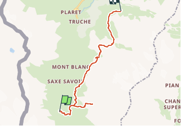
Tocht Stappen van 12,6 km beschikbaar op Valle d'Aosta, Onbekend, Valgrisenche. Deze tocht wordt voorgesteld door Patrick Costes .
Plaatsbepaling
Land:
Italy
Regio :
Valle d'Aosta
Departement/Provincie :
Onbekend
Gemeente :
Valgrisenche
Locatie:
Unknown
Vertrek:(Dec)
Vertrek:(UTM)
345268 ; 5044926 (32T) N.
Opmerkingen