


Pont lâAB V2

Pierrannick
Gebruiker
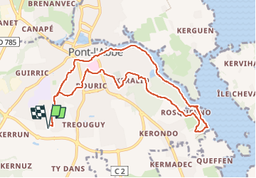

Lengte
10,1 km

Max. hoogte
22 m

Positief hoogteverschil
84 m
Km-Effort
11,2 km

Min. hoogte
-3 m

Negatief hoogteverschil
84 m
Boucle
Ja
Datum van aanmaak :
2025-07-30 08:50:44.0
Laatste wijziging :
2025-07-30 10:22:52.482
1h28
Moeilijkheid : Onbekend

Gratisgps-wandelapplicatie
 SityTrail
IGN / Geografische instituten
SityTrail Plus
De wereld gaat voor u open
Over ons
Tocht Lopen van 10,1 km beschikbaar op Bretagne, Finistère, Pont-l'Abbé. Deze tocht wordt voorgesteld door Pierrannick.
Plaatsbepaling
Land:
France
Regio :
Bretagne
Departement/Provincie :
Finistère
Gemeente :
Pont-l'Abbé
Locatie:
Unknown
Vertrek:(Dec)
Vertrek:(UTM)
407828 ; 5300759 (30T) N.
Opmerkingen