


2025-07-30 Dourdan - Bondoufle

Lucquiaud
Gebruiker
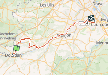

Lengte
46 km

Max. hoogte
170 m

Positief hoogteverschil
505 m
Km-Effort
52 km

Min. hoogte
39 m

Negatief hoogteverschil
530 m
Boucle
Neen
Datum van aanmaak :
2025-07-31 09:47:18.144
Laatste wijziging :
2025-07-31 18:01:36.371
3h38
Moeilijkheid : Zeer moeilijk

Gratisgps-wandelapplicatie
 SityTrail
IGN / Geografische instituten
SityTrail Plus
De wereld gaat voor u open
Over ons
Tocht Mountainbike van 46 km beschikbaar op Île-de-France, Essonne, Dourdan. Deze tocht wordt voorgesteld door Lucquiaud.

Plaatsbepaling
Land:
France
Regio :
Île-de-France
Departement/Provincie :
Essonne
Gemeente :
Dourdan
Locatie:
Unknown
Vertrek:(Dec)
Vertrek:(UTM)
427063 ; 5375609 (31U) N.
Opmerkingen