


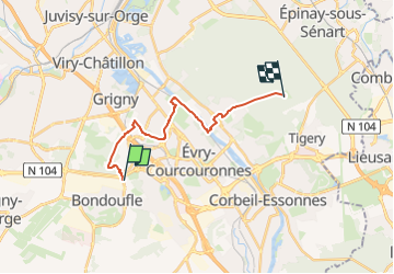
TourVTT-Bondoufle-Sénart-15692082

Lucquiaud
Gebruiker

Lengte
15 km

Max. hoogte
93 m

Positief hoogteverschil
133 m
Km-Effort
16,7 km

Min. hoogte
30 m

Negatief hoogteverschil
128 m
Boucle
Neen
Datum van aanmaak :
2025-07-31 19:07:49.267
Laatste wijziging :
2025-07-31 19:08:16.463
1h09
Moeilijkheid : Gemakkelijk

Gratisgps-wandelapplicatie
 SityTrail
IGN / Geografische instituten
SityTrail Plus
De wereld gaat voor u open
Over ons
Tocht Mountainbike van 15 km beschikbaar op Île-de-France, Essonne, Bondoufle. Deze tocht wordt voorgesteld door Lucquiaud.
Plaatsbepaling
Land:
France
Regio :
Île-de-France
Departement/Provincie :
Essonne
Gemeente :
Bondoufle
Locatie:
Unknown
Vertrek:(Dec)
Vertrek:(UTM)
455123 ; 5385591 (31U) N.
Opmerkingen