


31-07-2025 Milly- Boigneville

Lucquiaud
Gebruiker
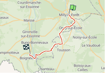

Lengte
16,2 km

Max. hoogte
126 m

Positief hoogteverschil
143 m
Km-Effort
18,1 km

Min. hoogte
63 m

Negatief hoogteverschil
141 m
Boucle
Neen
Datum van aanmaak :
2025-08-01 13:49:48.46
Laatste wijziging :
2025-08-01 15:21:39.534
1h17
Moeilijkheid : Gemakkelijk

Gratisgps-wandelapplicatie
 SityTrail
IGN / Geografische instituten
SityTrail Plus
De wereld gaat voor u open
Over ons
Tocht Mountainbike van 16,2 km beschikbaar op Île-de-France, Essonne, Milly-la-Forêt. Deze tocht wordt voorgesteld door Lucquiaud.
Plaatsbepaling
Land:
France
Regio :
Île-de-France
Departement/Provincie :
Essonne
Gemeente :
Milly-la-Forêt
Locatie:
Unknown
Vertrek:(Dec)
Vertrek:(UTM)
460764 ; 5361264 (31U) N.
Opmerkingen