


29_botsorhel_menhir

jab31
Gebruiker
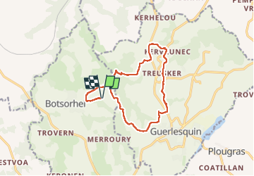

Lengte
13,9 km

Max. hoogte
254 m

Positief hoogteverschil
311 m
Km-Effort
18 km

Min. hoogte
125 m

Negatief hoogteverschil
311 m
Boucle
Ja
Datum van aanmaak :
2025-07-27 12:53:35.246
Laatste wijziging :
2025-08-02 19:25:54.914
3h04
Moeilijkheid : Medium

Gratisgps-wandelapplicatie
 SityTrail
IGN / Geografische instituten
SityTrail Plus
De wereld gaat voor u open
Over ons
Tocht Stappen van 13,9 km beschikbaar op Bretagne, Finistère, Botsorhel. Deze tocht wordt voorgesteld door jab31.
Beschrijving
le menhir de kerhellou
Plaatsbepaling
Land:
France
Regio :
Bretagne
Departement/Provincie :
Finistère
Gemeente :
Botsorhel
Locatie:
Unknown
Vertrek:(Dec)
Vertrek:(UTM)
453935 ; 5375210 (30U) N.
Opmerkingen