


barboursville river trail

quagmire1771
Gebruiker
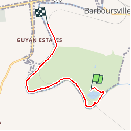

Lengte
6,1 km

Max. hoogte
183 m

Positief hoogteverschil
53 m
Km-Effort
6,9 km

Min. hoogte
161 m

Negatief hoogteverschil
61 m
Boucle
Neen
Datum van aanmaak :
2014-12-10 00:00:00.0
Laatste wijziging :
2014-12-10 00:00:00.0
--
Moeilijkheid : Onbekend

Gratisgps-wandelapplicatie
 SityTrail
IGN / Geografische instituten
SityTrail World
De wereld gaat voor u open
Over ons
Tocht Mountainbike van 6,1 km beschikbaar op West Virginia, Cabell County, Onbekend. Deze tocht wordt voorgesteld door quagmire1771.
Plaatsbepaling
Land:
United States
Regio :
West Virginia
Departement/Provincie :
Cabell County
Gemeente :
Onbekend
Locatie:
Barboursville
Vertrek:(Dec)
Vertrek:(UTM)
386441 ; 4249729 (17S) N.
Opmerkingen
Wandeltochten in de omgeving