Tocht Stappen Saint-Nazaire - 66 SAINT-NAZAIRE - CABESTANY promenade dans le vignoble de galets - Photo

66 SAINT-NAZAIRE - CABESTANY promenade dans le vignoble de galets

 jeff66
jeff66

Gebruiker

© OpenStreetMap contributors
Lengte
Lengte
9 km
Max. hoogte
Max. hoogte
34 m
Positief hoogteverschil
65 m
Km-Effort
Km-Effort  
9,9 km
Min. hoogte
Min. hoogte
-1 m
Negatief hoogteverschil
61 m
Boucle
Boucle
Ja
Datum van aanmaak :
2015-08-24 00:00:00.0
Laatste wijziging :
2015-08-24 00:00:00.0

(0 Bericht)

Stappen
Stappen
1h29
Moeilijkheid : Medium

Scan deze QR-code om de tocht te openen in de SityTrail-applicatie

Gratisgps-wandelapplicatie

Logo SityTrail SityTrail

IGN / Geografische instituten

SityTrail uit de App Store downloaden SityTrail uit Google Play downloaden

Logo SityTrail SityTrail World

De wereld gaat voor u open

SityTrail uit de App Store downloaden SityTrail uit Google Play downloaden SityTrail op Huawei AppGallery downloaden

Over ons

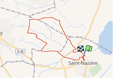
Tocht Stappen van 9 km beschikbaar op Occitanië, Pyrénées-Orientales, Saint-Nazaire. Deze tocht wordt voorgesteld door jeff66.

Beschrijving

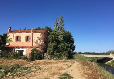
66 SAINT-NAZAIRE - parking des écoles et halle aux sports, avenue de Canet, camping les flamands roses, station de pompage, Solellop, château de Rey, mas d'en Sisquella, mas Victor, les Portes - Cabestany, chemin de Charlemagne, via Domitia, château de Lacroix, el mas'd'Alla - mas del Moli - SAINT-NAZAIRE, les garrigues, camp d'en Barrera, radier, stade marc-henri Tanyères, domaine de l'Arca, rue des amandiers, avenue de Paris, rue Serrat de madame. Rue de la mairie, rue du maréchal Joffre rue aristide Maillol, rue de l'église

Hoogteprofiel

Foto's

Plaatsbepaling

Land:
France
Regio :
Occitanië
Departement/Provincie :
Pyrénées-Orientales
Gemeente :
Saint-Nazaire
Locatie:
Unknown
Vertrek:(Dec)
Vertrek:(UTM)
499310 ; 4724252 (31T) N.

Wandeltochten in de omgeving

Tocht Stappen Théza - 66 THEZA - CORNEILLA-DEL-VERCOL - Photo
Stappen
jeff66

Stappen

Gemakkelijk
(2)
Théza, Occitanië, Pyrénées-Orientales, France
7 km | 7,5 km-effort
1h 8min
Ja
Tocht Stappen Saint-Cyprien - SAINT-CYPRIEN 66 - front de mer - les CAPELLANS - Photo
Stappen
jeff66

Stappen

Gemakkelijk
(2)
Saint-Cyprien, Occitanië, Pyrénées-Orientales, France
9,9 km | 10,3 km-effort
2h 11min
Ja
Tocht Paard Saint-Cyprien - bocal du Tech - Photo
Paard
sandymocko

Paard

Medium
(1)
Saint-Cyprien, Occitanië, Pyrénées-Orientales, France
17 km | 17,7 km-effort
3h 20min
Ja
Tocht Stappen Cabestany - Chemins autour de Cabestany - Photo
Stappen
tracegps

Stappen

Medium
(2)
Cabestany, Occitanië, Pyrénées-Orientales, France
11,8 km | 12,7 km-effort
3h 0min
Ja
Tocht Stappen Saleilles - 66 SALEILLES - St-NAZAIRE, entre FOSSEILLE et REART - Photo
Stappen
jeff66

Stappen

Gemakkelijk
(1)
Saleilles, Occitanië, Pyrénées-Orientales, France
7,3 km | 7,7 km-effort
1h 8min
Ja
Tocht Stappen Corneilla-del-Vercol - CORNEILLA-DEL-VERCOL 66 - THEZA - l'Agouille de la Mar - le VERCOL - Photo
Stappen
jeff66

Stappen

Gemakkelijk
(1)
Corneilla-del-Vercol, Occitanië, Pyrénées-Orientales, France
12,3 km | 13,1 km-effort
2h 12min
Ja
Tocht Stappen Canet-en-Roussillon - CANET-EN-ROUSSILLON 66 - entre TÊT, marais. étang et RÉART  - Photo
Stappen
jeff66

Stappen

Medium
(1)
Canet-en-Roussillon, Occitanië, Pyrénées-Orientales, France
16,3 km | 17,5 km-effort
2h 49min
Ja
Tocht Stappen Canet-en-Roussillon - CANET-EN-ROUSSILLON 66 - entre mer, plage, dunes et étang - SAINT-CYPRIEN-PLAGE - Photo
Stappen
jeff66

Stappen

Medium
Canet-en-Roussillon, Occitanië, Pyrénées-Orientales, France
12,5 km | 12,9 km-effort
2h 14min
Ja
Tocht Stappen Elne - ALENYA 66 - entre l'Agouille de la Mar et le Réart - Photo
Stappen
jeff66

Stappen

Gemakkelijk
Elne, Occitanië, Pyrénées-Orientales, France
12,6 km | 13,1 km-effort
1h 57min
Ja


Sluiten
Mijn abonnementen