


Circuit LB aubure-thannenkirch

Tourisme Equestre Alsace
Promouvoir le Tourisme Equestre en Alsace GUIDE+
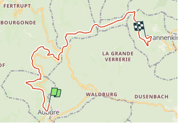

Lengte
15,9 km

Max. hoogte
916 m

Positief hoogteverschil
498 m
Km-Effort
23 km

Min. hoogte
584 m

Negatief hoogteverschil
624 m
Boucle
Neen
Datum van aanmaak :
2015-10-01 00:00:00.0
Laatste wijziging :
2023-07-14 17:37:32.059
2h37
Moeilijkheid : Gemakkelijk

Gratisgps-wandelapplicatie
 SityTrail
IGN / Geografische instituten
SityTrail Plus
De wereld gaat voor u open
Over ons
Tocht Paardrijden van 15,9 km beschikbaar op Grand Est, Haut-Rhin, Aubure. Deze tocht wordt voorgesteld door Tourisme Equestre Alsace.
Foto's


Plaatsbepaling
Land:
France
Regio :
Grand Est
Departement/Provincie :
Haut-Rhin
Gemeente :
Aubure
Locatie:
Unknown
Vertrek:(Dec)
Vertrek:(UTM)
367901 ; 5340252 (32U) N.
Opmerkingen