


CAMPS LA SOURCE LES CHATAIGNIERS - 10KM

jpb83
Gebruiker
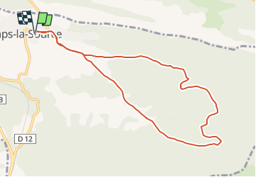

Lengte
10,5 km

Max. hoogte
420 m

Positief hoogteverschil
279 m
Km-Effort
14,2 km

Min. hoogte
272 m

Negatief hoogteverschil
280 m
Boucle
Ja
Datum van aanmaak :
2016-08-07 00:00:00.0
Laatste wijziging :
2016-08-07 00:00:00.0
1h10
Moeilijkheid : Medium

Gratisgps-wandelapplicatie
 SityTrail
IGN / Geografische instituten
SityTrail Plus
De wereld gaat voor u open
Over ons
Tocht Lopen van 10,5 km beschikbaar op Provence-Alpes-Côte d'Azur, Var, Camps-la-Source. Deze tocht wordt voorgesteld door jpb83.
Plaatsbepaling
Land:
France
Regio :
Provence-Alpes-Côte d'Azur
Departement/Provincie :
Var
Gemeente :
Camps-la-Source
Locatie:
Unknown
Vertrek:(Dec)
Vertrek:(UTM)
265062 ; 4807640 (32T) N.
Opmerkingen