


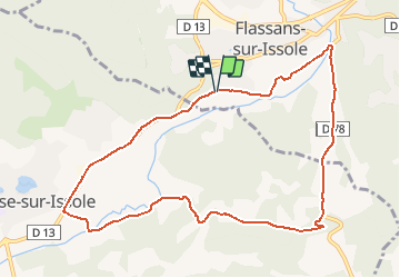
FLASSANS - BESSE - 10KM7

jpb83
Gebruiker

Lengte
10,7 km

Max. hoogte
281 m

Positief hoogteverschil
132 m
Km-Effort
12,5 km

Min. hoogte
225 m

Negatief hoogteverschil
135 m
Boucle
Ja
Datum van aanmaak :
2015-11-08 00:00:00.0
Laatste wijziging :
2015-11-08 00:00:00.0
1h00
Moeilijkheid : Gemakkelijk

Gratisgps-wandelapplicatie
 SityTrail
IGN / Geografische instituten
SityTrail Plus
De wereld gaat voor u open
Over ons
Tocht Lopen van 10,7 km beschikbaar op Provence-Alpes-Côte d'Azur, Var, Flassans-sur-Issole. Deze tocht wordt voorgesteld door jpb83.
Plaatsbepaling
Land:
France
Regio :
Provence-Alpes-Côte d'Azur
Departement/Provincie :
Var
Gemeente :
Flassans-sur-Issole
Locatie:
Unknown
Vertrek:(Dec)
Vertrek:(UTM)
273558 ; 4804773 (32T) N.
Opmerkingen