


2015 11 08 CROSS LONG

staubalex
Gebruiker

Lengte
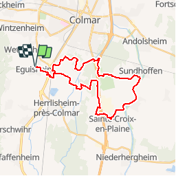
31 km

Max. hoogte
202 m

Positief hoogteverschil
172 m
Km-Effort
33 km

Min. hoogte
184 m

Negatief hoogteverschil
172 m
Boucle
Ja
Datum van aanmaak :
2015-11-07 00:00:00.0
Laatste wijziging :
2015-11-07 00:00:00.0
2h14
Moeilijkheid : Medium

Gratisgps-wandelapplicatie
 SityTrail
IGN / Geografische instituten
SityTrail Plus
De wereld gaat voor u open
Over ons
Tocht Mountainbike van 31 km beschikbaar op Grand Est, Haut-Rhin, Eguisheim. Deze tocht wordt voorgesteld door staubalex.
Plaatsbepaling
Land:
France
Regio :
Grand Est
Departement/Provincie :
Haut-Rhin
Gemeente :
Eguisheim
Locatie:
Unknown
Vertrek:(Dec)
Vertrek:(UTM)
373954 ; 5322812 (32U) N.
Opmerkingen