


Restinclières-Beaulieu

JEANJOSY
Gebruiker
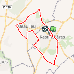

Lengte
8,7 km

Max. hoogte
106 m

Positief hoogteverschil
104 m
Km-Effort
10,1 km

Min. hoogte
62 m

Negatief hoogteverschil
104 m
Boucle
Ja
Datum van aanmaak :
2015-11-14 00:00:00.0
Laatste wijziging :
2015-11-14 00:00:00.0
2h20
Moeilijkheid : Heel gemakkelijk

Gratisgps-wandelapplicatie
 SityTrail
IGN / Geografische instituten
SityTrail Plus
De wereld gaat voor u open
Over ons
Tocht Stappen van 8,7 km beschikbaar op Occitanië, Hérault, Restinclières. Deze tocht wordt voorgesteld door JEANJOSY.
Plaatsbepaling
Land:
France
Regio :
Occitanië
Departement/Provincie :
Hérault
Gemeente :
Restinclières
Locatie:
Unknown
Vertrek:(Dec)
Vertrek:(UTM)
583416 ; 4841792 (31T) N.
Opmerkingen
Énormément de routes goudronnées