Tocht Stappen Onhaye - De Gérin à Anthée par le village de Maurenne - Photo

De Gérin à Anthée par le village de Maurenne

 Desrumaux
Desrumaux

Gebruiker GUIDE

© OpenStreetMap contributors
Lengte
Lengte
18,1 km
Max. hoogte
Max. hoogte
274 m
Positief hoogteverschil
336 m
Km-Effort
Km-Effort  
23 km
Min. hoogte
Min. hoogte
161 m
Negatief hoogteverschil
337 m
Boucle
Boucle
Ja
Datum van aanmaak :
2014-12-10 00:00:00.0
Laatste wijziging :
2014-12-10 00:00:00.0

(1 Bericht)

Stappen
Stappen
4h10
Moeilijkheid : Medium

Scan deze QR-code om de tocht te openen in de SityTrail-applicatie

Gratisgps-wandelapplicatie

Logo SityTrail SityTrail

IGN / Geografische instituten

SityTrail uit de App Store downloaden SityTrail uit Google Play downloaden

Logo SityTrail SityTrail World

De wereld gaat voor u open

SityTrail uit de App Store downloaden SityTrail uit Google Play downloaden SityTrail op Huawei AppGallery downloaden

Over ons

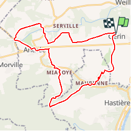
Tocht Stappen van 18,1 km beschikbaar op Wallonië, Namen, Onhaye. Deze tocht wordt voorgesteld door Desrumaux.

Beschrijving

ANTHEE est un charmant petit village situé dans la commune d’Onhaye, sur les hauteurs de Dinant.
C'est à Anthée, au XIXe s, que fut découverte une des plus importantes villas gallo-romaines du pays. Composé du XVIe au début XVIIIe siècle, le château-ferme de la Forge de style français du XVIIIe siècle est une construction en U, faite de calcaire, brique et pierre bleue. Le château d’Ostemerée aux clochetons élégants est du début du XXème siècle

MAURENNE est caractérisé par la présence de deux grosses fermes dont l'une prend l'allure de château. Belles maisons en pierres de pays.

Ce petit havre de paix avec seulement 60 habitants se situe sur un petit promontoire longé par le ruisseau « Le Feron ». Le relief y est très accidenté.

Départ : Eglise de Gérin ou église d’Anthée.

Détails sur TraceGPS.com

http://www.tracegps.com/fr/parcours/circuit9276.htm#

Hoogteprofiel

Plaatsbepaling

Land:
Belgium
Regio :
Wallonië
Departement/Provincie :
Namen
Gemeente :
Onhaye
Locatie:
Gerin
Vertrek:(Dec)
Vertrek:(UTM)
629451 ; 5567587 (31U) N.

Opmerkingen

Gelieve in te loggen om een commentaar of een beoordeling achter te laten


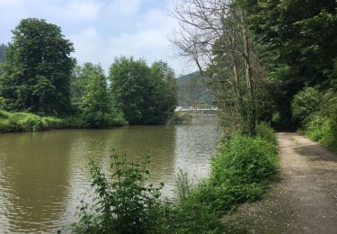
très belle randonnée variée


Wandeltochten in de omgeving

Tocht Stappen Onhaye - RB-Na-C2-Sommière-Complet_20,4km - Photo
Stappen
PRO

Stappen

Zeer moeilijk
(2)
Onhaye, Wallonië, Namen, Belgium
20 km | 25 km-effort
5h 25min
Ja
Tocht Stappen Hastière - Balade de Hastière à Waulsort - Photo
Stappen
GUIDE
Desrumaux

Stappen

Medium
(2)
Hastière, Wallonië, Namen, Belgium
10,8 km | 13,8 km-effort
3h 2min
Ja
Tocht Stappen Hastière - RB-Na-10 Raccourci 2 - Sur les crêtes mosanes - Photo
Stappen
PRO

Stappen

Gemakkelijk
(2)
Hastière, Wallonië, Namen, Belgium
18,1 km | 25 km-effort
4h 29min
Ja
Tocht Stappen Hastière - RB-Na-10 Raccourci 1 - Sur les crêtes mosanes - Photo
Stappen
PRO

Stappen

Medium
(3)
Hastière, Wallonië, Namen, Belgium
15,3 km | 21 km-effort
5h 28min
Ja
Tocht Stappen Hastière - RB-Na-10 - Sur les crêtes mosanes - Photo
Stappen
PRO

Stappen

Medium
(4)
Hastière, Wallonië, Namen, Belgium
22 km | 29 km-effort
6h 21min
Ja
Tocht Stappen Onhaye - RB-Na-C2-Sommière-Raccourci_13,1km - Photo
Stappen
PRO

Stappen

Moeilijk
(5)
Onhaye, Wallonië, Namen, Belgium
13 km | 16,2 km-effort
3h 29min
Ja
Tocht Stappen Hastière - Hastiere - Photo
Stappen
DoBelle

Stappen

Moeilijk
(1)
Hastière, Wallonië, Namen, Belgium
32 km | 41 km-effort
6h 22min
Ja
Tocht Stappen Hastière - Balade de Hastière à Hermeton - Photo
Stappen
GUIDE
Desrumaux

Stappen

Gemakkelijk
(1)
Hastière, Wallonië, Namen, Belgium
13,1 km | 16,8 km-effort
3h 37min
Ja
Tocht Stappen Hastière - Waulsort - Circuit Natura 2000, des sites qui valent le détour - Na08 - Photo
Stappen
GUIDE+

Stappen

Heel gemakkelijk
(4)
Hastière, Wallonië, Namen, Belgium
4,5 km | 6,9 km-effort
1h 40min
Ja


Sluiten
Mijn abonnementen