


Senlis Courteuil données PNR

gilbertdu60
Gebruiker
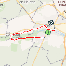

Lengte
8,7 km

Max. hoogte
74 m

Positief hoogteverschil
79 m
Km-Effort
9,8 km

Min. hoogte
43 m

Negatief hoogteverschil
73 m
Boucle
Neen
Datum van aanmaak :
2016-01-15 00:00:00.0
Laatste wijziging :
2016-01-15 00:00:00.0
34m
Moeilijkheid : Medium

Gratisgps-wandelapplicatie
 SityTrail
IGN / Geografische instituten
SityTrail Plus
De wereld gaat voor u open
Over ons
Tocht Fiets van 8,7 km beschikbaar op Hauts-de-France, Oise, Senlis. Deze tocht wordt voorgesteld door gilbertdu60.
Beschrijving
balade de Senlis à Courteuil retour Senlis
Plaatsbepaling
Land:
France
Regio :
Hauts-de-France
Departement/Provincie :
Oise
Gemeente :
Senlis
Locatie:
Unknown
Vertrek:(Dec)
Vertrek:(UTM)
469185 ; 5449266 (31U) N.
Opmerkingen