


Tasie - Vélo - 1

frizou83
Gebruiker
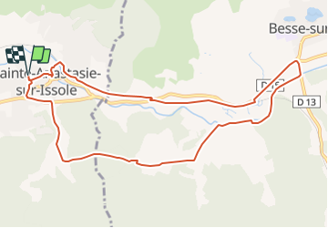

Lengte
11,4 km

Max. hoogte
340 m

Positief hoogteverschil
151 m
Km-Effort
13,4 km

Min. hoogte
248 m

Negatief hoogteverschil
151 m
Boucle
Ja
Datum van aanmaak :
2016-01-24 00:00:00.0
Laatste wijziging :
2016-01-24 00:00:00.0
46m
Moeilijkheid : Onbekend

Gratisgps-wandelapplicatie
 SityTrail
IGN / Geografische instituten
SityTrail Plus
De wereld gaat voor u open
Over ons
Tocht Fiets van 11,4 km beschikbaar op Provence-Alpes-Côte d'Azur, Var, Sainte-Anastasie-sur-Issole. Deze tocht wordt voorgesteld door frizou83.
Plaatsbepaling
Land:
France
Regio :
Provence-Alpes-Côte d'Azur
Departement/Provincie :
Var
Gemeente :
Sainte-Anastasie-sur-Issole
Locatie:
Unknown
Vertrek:(Dec)
Vertrek:(UTM)
266726 ; 4802913 (32T) N.
Opmerkingen