


Chateauneuf en Thymerais 7

togolo28
Gebruiker
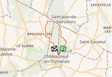

Lengte
7,6 km

Max. hoogte
217 m

Positief hoogteverschil
71 m
Km-Effort
8,6 km

Min. hoogte
181 m

Negatief hoogteverschil
72 m
Boucle
Ja
Datum van aanmaak :
2016-03-09 00:00:00.0
Laatste wijziging :
2018-10-15 16:29:29.536
1h53
Moeilijkheid : Gemakkelijk

Gratisgps-wandelapplicatie
 SityTrail
IGN / Geografische instituten
SityTrail Plus
De wereld gaat voor u open
Over ons
Tocht Stappen van 7,6 km beschikbaar op Centre-Val de Loire, Eure-et-Loir, Châteauneuf-en-Thymerais. Deze tocht wordt voorgesteld door togolo28.
Plaatsbepaling
Land:
France
Regio :
Centre-Val de Loire
Departement/Provincie :
Eure-et-Loir
Gemeente :
Châteauneuf-en-Thymerais
Locatie:
Unknown
Vertrek:(Dec)
Vertrek:(UTM)
370477 ; 5382906 (31U) N.
Opmerkingen