


Compeyre

ARPF
Gebruiker
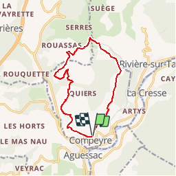

Lengte
12,7 km

Max. hoogte
628 m

Positief hoogteverschil
348 m
Km-Effort
17,3 km

Min. hoogte
434 m

Negatief hoogteverschil
333 m
Boucle
Ja
Datum van aanmaak :
2016-03-09 00:00:00.0
Laatste wijziging :
2016-03-09 00:00:00.0
3h20
Moeilijkheid : Medium

Gratisgps-wandelapplicatie
 SityTrail
IGN / Geografische instituten
SityTrail Plus
De wereld gaat voor u open
Over ons
Tocht Stappen van 12,7 km beschikbaar op Occitanië, Aveyron, Compeyre. Deze tocht wordt voorgesteld door ARPF.
Beschrijving
Compeyre
le Puech de Luzergue
Plaatsbepaling
Land:
France
Regio :
Occitanië
Departement/Provincie :
Aveyron
Gemeente :
Compeyre
Locatie:
Unknown
Vertrek:(Dec)
Vertrek:(UTM)
508214 ; 4889928 (31T) N.
Opmerkingen
les trois châteaux