


09 - 28 février 2016 GRBA

ace003
Gebruiker

Lengte
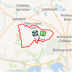
23 km

Max. hoogte
152 m

Positief hoogteverschil
178 m
Km-Effort
25 km

Min. hoogte
106 m

Negatief hoogteverschil
178 m
Boucle
Ja
Datum van aanmaak :
2016-03-09 00:00:00.0
Laatste wijziging :
2016-03-09 00:00:00.0
6h40
Moeilijkheid : Gemakkelijk

Gratisgps-wandelapplicatie
 SityTrail
IGN / Geografische instituten
SityTrail Plus
De wereld gaat voor u open
Over ons
Tocht Stappen van 23 km beschikbaar op Grand Est, Aube, Épagne. Deze tocht wordt voorgesteld door ace003.
Plaatsbepaling
Land:
France
Regio :
Grand Est
Departement/Provincie :
Aube
Gemeente :
Épagne
Locatie:
Unknown
Vertrek:(Dec)
Vertrek:(UTM)
608388 ; 5361015 (31U) N.
Opmerkingen