7 km | 7,5 km-effort
66 PERPIGNAN, quartier MAV au Bas Vernet
jeff66
Gebruiker
Lengte
10,7 km
Max. hoogte
66 m
Positief hoogteverschil
87 m
Km-Effort
11,8 km
Min. hoogte
24 m
Negatief hoogteverschil
87 m
Boucle
Ja
Datum van aanmaak :
2016-03-22 00:00:00.0
Laatste wijziging :
2016-03-22 00:00:00.0
1h45
Moeilijkheid : Gemakkelijk
Gratisgps-wandelapplicatie
Over ons
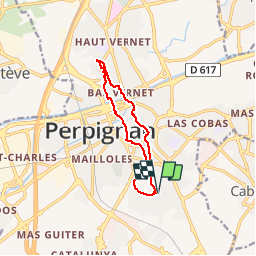
Tocht Stappen van 10,7 km beschikbaar op Occitanië, Pyrénées-Orientales, Perpignan. Deze tocht wordt voorgesteld door jeff66.
Beschrijving
66 PERPIGNAN, quartier MAV au Bas Vernet
Plaatsbepaling
Land:
France
Regio :
Occitanië
Departement/Provincie :
Pyrénées-Orientales
Gemeente :
Perpignan
Locatie:
Unknown
Vertrek:(Dec)
Vertrek:(UTM)
492168 ; 4725216 (31T) N.
Opmerkingen
Wandeltochten in de omgeving
66 THEZA - CORNEILLA-DEL-VERCOL
Stappen
Gemakkelijk
(2)
Théza,
Occitanië,
Pyrénées-Orientales,
France
1h 8min
Ja
Chemins autour de Cabestany
Stappen
Medium
(2)
Cabestany,
Occitanië,
Pyrénées-Orientales,
France
11,8 km | 12,7 km-effort
3h 0min
Ja
Perpignan 01.10.2017
Stappen
Gemakkelijk
(1)
Perpignan,
Occitanië,
Pyrénées-Orientales,
France
6,7 km | 7,5 km-effort
1h 39min
Neen
66 VILLENEUVE-DE-LA-RAHO - grand tour périphérique du lac par les lignes de c...
Stappen
Gemakkelijk
(2)
Villeneuve-de-la-Raho,
Occitanië,
Pyrénées-Orientales,
France
10 km | 11,5 km-effort
1h 44min
Ja
66 SALEILLES - St-NAZAIRE, entre FOSSEILLE et REART
Stappen
Gemakkelijk
(1)
Saleilles,
Occitanië,
Pyrénées-Orientales,
France
7,3 km | 7,7 km-effort
1h 8min
Ja
Perpignan
Stappen
Heel gemakkelijk
Perpignan,
Occitanië,
Pyrénées-Orientales,
France
18 km | 19,9 km-effort
2h 23min
Neen
canal Perpignan
Stappen
Heel gemakkelijk
Perpignan,
Occitanië,
Pyrénées-Orientales,
France
25 km | 27 km-effort
7h 29min
Neen
66 Perpignan Panchot centre bas Vernet centre del mon
Stappen
Gemakkelijk
Perpignan,
Occitanië,
Pyrénées-Orientales,
France
8,6 km | 9,3 km-effort
1h 29min
Ja
66 BOMPAS - itinéraire partagé piétions cycliste en bord de Tet, berge Têt, B...
Stappen
Medium
Bompas,
Occitanië,
Pyrénées-Orientales,
France
13,4 km | 14,2 km-effort
2h 23min
Ja