


Cascade du Sautadet

frizou83
Gebruiker

Lengte
9,1 km

Max. hoogte
109 m

Positief hoogteverschil
161 m
Km-Effort
11,3 km

Min. hoogte
51 m

Negatief hoogteverschil
155 m
Boucle
Neen
Datum van aanmaak :
2016-03-28 00:00:00.0
Laatste wijziging :
2016-03-28 00:00:00.0
2h29
Moeilijkheid : Gemakkelijk

Gratisgps-wandelapplicatie
 SityTrail
IGN / Geografische instituten
SityTrail Plus
De wereld gaat voor u open
Over ons
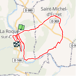
Tocht Stappen van 9,1 km beschikbaar op Occitanië, Gard, La Roque-sur-Cèze. Deze tocht wordt voorgesteld door frizou83.
Beschrijving
Séjour à Saint-André
Plaatsbepaling
Land:
France
Regio :
Occitanië
Departement/Provincie :
Gard
Gemeente :
La Roque-sur-Cèze
Locatie:
Unknown
Vertrek:(Dec)
Vertrek:(UTM)
621767 ; 4894518 (31T) N.
Opmerkingen