


parcours vers lachamp

Quentin48
Gebruiker
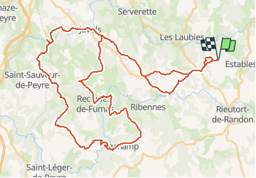

Lengte
65 km

Max. hoogte
1180 m

Positief hoogteverschil
1300 m
Km-Effort
82 km

Min. hoogte
862 m

Negatief hoogteverschil
1299 m
Boucle
Ja
Datum van aanmaak :
2016-03-30 00:00:00.0
Laatste wijziging :
2016-03-30 00:00:00.0
4h30
Moeilijkheid : Moeilijk

Gratisgps-wandelapplicatie
 SityTrail
IGN / Geografische instituten
SityTrail Plus
De wereld gaat voor u open
Over ons
Tocht Mountainbike van 65 km beschikbaar op Occitanië, Lozère, Monts-de-Randon. Deze tocht wordt voorgesteld door Quentin48.
Beschrijving
Passage difficile après le moulin de Lachamp
Plaatsbepaling
Land:
France
Regio :
Occitanië
Departement/Provincie :
Lozère
Gemeente :
Monts-de-Randon
Locatie:
Saint-Amans
Vertrek:(Dec)
Vertrek:(UTM)
536877 ; 4946480 (31T) N.
Opmerkingen