Tocht Stappen Espira-de-l'Agly - 66 CASES DE PÈNE - ESPIRA DE L'AGLY - ballade en bords et vallée d'Agly - Photo

66 CASES DE PÈNE - ESPIRA DE L'AGLY - ballade en bords et vallée d'Agly

 jeff66
jeff66

Gebruiker

© OpenStreetMap contributors
Lengte
Lengte
12,8 km
Max. hoogte
Max. hoogte
76 m
Positief hoogteverschil
132 m
Km-Effort
Km-Effort  
14,5 km
Min. hoogte
Min. hoogte
22 m
Negatief hoogteverschil
132 m
Boucle
Boucle
Ja
Datum van aanmaak :
2016-04-18 00:00:00.0
Laatste wijziging :
2016-04-18 00:00:00.0

(0 Bericht)

Stappen
Stappen
2h23
Moeilijkheid : Medium

Scan deze QR-code om de tocht te openen in de SityTrail-applicatie

Gratisgps-wandelapplicatie

Logo SityTrail SityTrail

IGN / Geografische instituten

SityTrail uit de App Store downloaden SityTrail uit Google Play downloaden

Logo SityTrail SityTrail Plus

De wereld gaat voor u open

SityTrail uit de App Store downloaden SityTrail uit Google Play downloaden SityTrail op Huawei AppGallery downloaden

Over ons

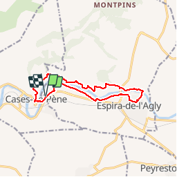
Tocht Stappen van 12,8 km beschikbaar op Occitanië, Pyrénées-Orientales, Espira-de-l'Agly. Deze tocht wordt voorgesteld door jeff66.

Beschrijving

66 CASES DE PÈNE - Parking A proximité zone de loisirs et cave en Bord de la RD117 - Mas Ferriol - le relais de Marie - els Vinyers Baixos - ESPIRA DE L'AGLY - chemin du Garriga  - rue du pont - Eglise Ste Marie - rue ND des Anges - rue Pasteur - radier sur l'Agly - Serrat de la Devesa - Correc Dels Tamarius - Mas Cremat - mas Mirs - CASE DE P. - el camp del Colom - el camp del Fuster - cimetiere - rue Victor Hugo - mairie - école - pont sur l'agly - longer la Rd117

Hoogteprofiel

Plaatsbepaling

Land:
France
Regio :
Occitanië
Departement/Provincie :
Pyrénées-Orientales
Gemeente :
Espira-de-l'Agly
Locatie:
Unknown
Vertrek:(Dec)
Vertrek:(UTM)
482904 ; 4736469 (31T) N.


Sluiten
Mijn abonnementen