


fournes tavel

mthomas30
Gebruiker
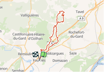

Lengte
32 km

Max. hoogte
247 m

Positief hoogteverschil
536 m
Km-Effort
39 km

Min. hoogte
48 m

Negatief hoogteverschil
533 m
Boucle
Ja
Datum van aanmaak :
2016-04-23 00:00:00.0
Laatste wijziging :
2016-04-23 00:00:00.0
3h38
Moeilijkheid : Onbekend

Gratisgps-wandelapplicatie
 SityTrail
IGN / Geografische instituten
SityTrail Plus
De wereld gaat voor u open
Over ons
Tocht Mountainbike van 32 km beschikbaar op Occitanië, Gard, Fournès. Deze tocht wordt voorgesteld door mthomas30.
Beschrijving
vtt technique
Plaatsbepaling
Land:
France
Regio :
Occitanië
Departement/Provincie :
Gard
Gemeente :
Fournès
Locatie:
Unknown
Vertrek:(Dec)
Vertrek:(UTM)
628606 ; 4865162 (31T) N.
Opmerkingen