


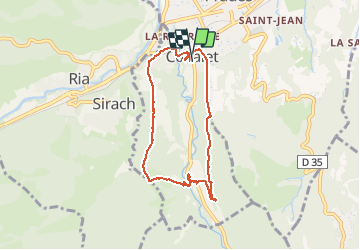
66 CODALET - St Michel de Cuxa Abbaye

jeff66
Gebruiker


1h53
Moeilijkheid : Medium

Gratisgps-wandelapplicatie
 SityTrail
IGN / Geografische instituten
SityTrail Plus
De wereld gaat voor u open
Over ons
Tocht Stappen van 7,8 km beschikbaar op Occitanië, Pyrénées-Orientales, Codalet. Deze tocht wordt voorgesteld door jeff66.
Beschrijving
66 CODALET centre ville mairie, rue du Conflent, chemin de Nogarol, mas la pastorale, mas Ribes, mas des Forques, canal d'irrigation, mas Raffa, siphon, ermitage de St Pierre, abbaye St Michel de Cuxa, passerelle sur la LLitéra, la clote, le Canal de Bohère, chapelle St Jean, St Augustin, traverser la voie ferrée suivre la RD27a, passer sous le pont du chemin de fer, rentrer dans CODALET par la rue du Conflent, places du fort, de la république, rue du Canigo
Foto's


27 fotos in totaal. Klik op een foto om ze allemaal in de galerij weer te geven.
Plaatsbepaling
Opmerkingen