


04.05.2016 - CAMPEL Nord et Est

babeth35
Gebruiker
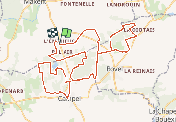

Lengte
28 km

Max. hoogte
139 m

Positief hoogteverschil
366 m
Km-Effort
33 km

Min. hoogte
79 m

Negatief hoogteverschil
365 m
Boucle
Ja
Datum van aanmaak :
2016-05-04 00:00:00.0
Laatste wijziging :
2020-07-20 15:33:08.551
6h25
Moeilijkheid : Medium

Gratisgps-wandelapplicatie
 SityTrail
IGN / Geografische instituten
SityTrail Plus
De wereld gaat voor u open
Over ons
Tocht Stappen van 28 km beschikbaar op Bretagne, Ille-et-Vilaine, Maxent. Deze tocht wordt voorgesteld door babeth35.
Plaatsbepaling
Land:
France
Regio :
Bretagne
Departement/Provincie :
Ille-et-Vilaine
Gemeente :
Maxent
Locatie:
Unknown
Vertrek:(Dec)
Vertrek:(UTM)
573470 ; 5312586 (30T) N.
Opmerkingen