


DIOIS 3J J1 1605

azipat
Gebruiker
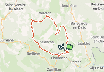

Lengte
36 km

Max. hoogte
1418 m

Positief hoogteverschil
1463 m
Km-Effort
55 km

Min. hoogte
545 m

Negatief hoogteverschil
1449 m
Boucle
Ja
Datum van aanmaak :
2016-05-12 00:00:00.0
Laatste wijziging :
2016-05-12 00:00:00.0
6h45
Moeilijkheid : Medium

Gratisgps-wandelapplicatie
 SityTrail
IGN / Geografische instituten
SityTrail Plus
De wereld gaat voor u open
Over ons
Tocht Paard van 36 km beschikbaar op Auvergne-Rhône-Alpes, Drôme, La Motte-Chalancon. Deze tocht wordt voorgesteld door azipat.
Plaatsbepaling
Land:
France
Regio :
Auvergne-Rhône-Alpes
Departement/Provincie :
Drôme
Gemeente :
La Motte-Chalancon
Locatie:
Unknown
Vertrek:(Dec)
Vertrek:(UTM)
690420 ; 4929032 (31T) N.
Opmerkingen