J3 St Jean des Balmes Ermitage St Michel

ARPF
Gebruiker
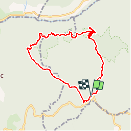

Lengte
9,6 km

Max. hoogte
903 m

Positief hoogteverschil
323 m
Km-Effort
13,9 km

Min. hoogte
677 m

Negatief hoogteverschil
319 m
Boucle
Ja
Datum van aanmaak :
2016-06-09 00:00:00.0
Laatste wijziging :
2016-06-09 00:00:00.0
3h18
Moeilijkheid : Gemakkelijk

Gratisgps-wandelapplicatie
 SityTrail
IGN / Geografische instituten
SityTrail Plus
De wereld gaat voor u open
Over ons
Tocht Stappen van 9,6 km beschikbaar op Occitanië, Aveyron, Veyreau. Deze tocht wordt voorgesteld door ARPF.
Beschrijving
P2 T2 Belle rando, facile, sur le plateau du Cause Noir. Très belle vue sut les Gorges de la Jonte.
Passages étroits au bord des Gorges de la Jonte.
Plaatsbepaling
Land:
France
Regio :
Occitanië
Departement/Provincie :
Aveyron
Gemeente :
Veyreau
Locatie:
Unknown
Vertrek:(Dec)
Vertrek:(UTM)
519597 ; 4890994 (31T) N.
Opmerkingen