


champlon-Lamouline

gk@icedd.be
Gebruiker
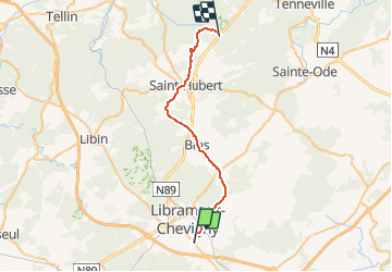

Lengte
27 km

Max. hoogte
574 m

Positief hoogteverschil
572 m
Km-Effort
34 km

Min. hoogte
399 m

Negatief hoogteverschil
455 m
Boucle
Neen
Datum van aanmaak :
2016-05-22 00:00:00.0
Laatste wijziging :
2016-05-22 00:00:00.0
1h58
Moeilijkheid : Onbekend

Gratisgps-wandelapplicatie
 SityTrail
IGN / Geografische instituten
SityTrail Plus
De wereld gaat voor u open
Over ons
Tocht Fiets van 27 km beschikbaar op Wallonië, Luxemburg, Libramont-Chevigny. Deze tocht wordt voorgesteld door gk@icedd.be.
Plaatsbepaling
Land:
Belgium
Regio :
Wallonië
Departement/Provincie :
Luxemburg
Gemeente :
Libramont-Chevigny
Locatie:
Saint-Pierre
Vertrek:(Dec)
Vertrek:(UTM)
671259 ; 5529841 (31U) N.
Opmerkingen