


abaye de Chaaly

LaurentBernard
Gebruiker
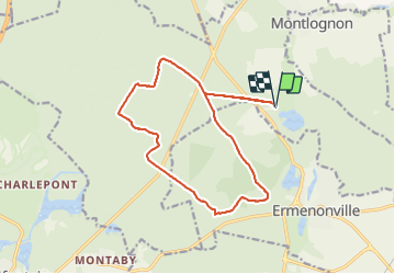

Lengte
15 km

Max. hoogte
127 m

Positief hoogteverschil
169 m
Km-Effort
17,2 km

Min. hoogte
70 m

Negatief hoogteverschil
169 m
Boucle
Ja
Datum van aanmaak :
2017-11-09 00:00:00.0
Laatste wijziging :
2017-11-09 00:00:00.0
3h46
Moeilijkheid : Medium

Gratisgps-wandelapplicatie
 SityTrail
IGN / Geografische instituten
SityTrail Plus
De wereld gaat voor u open
Over ons
Tocht Stappen van 15 km beschikbaar op Hauts-de-France, Oise, Fontaine-Chaalis. Deze tocht wordt voorgesteld door LaurentBernard.
Plaatsbepaling
Land:
France
Regio :
Hauts-de-France
Departement/Provincie :
Oise
Gemeente :
Fontaine-Chaalis
Locatie:
Unknown
Vertrek:(Dec)
Vertrek:(UTM)
476887 ; 5443840 (31U) N.
Opmerkingen