


Ninglinspo - Vert Buisson - Fond des Quarreux

Koa1a
Gebruiker
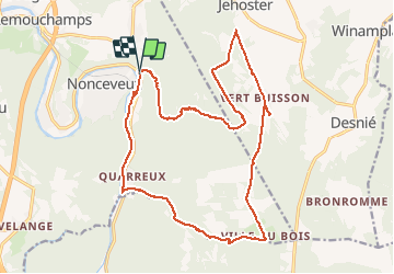

Lengte
20 km

Max. hoogte
477 m

Positief hoogteverschil
419 m
Km-Effort
26 km

Min. hoogte
154 m

Negatief hoogteverschil
415 m
Boucle
Ja
Datum van aanmaak :
2016-05-26 00:00:00.0
Laatste wijziging :
2016-05-26 00:00:00.0
5h22
Moeilijkheid : Medium

Gratisgps-wandelapplicatie
 SityTrail
IGN / Geografische instituten
SityTrail Plus
De wereld gaat voor u open
Over ons
Tocht Stappen van 20 km beschikbaar op Wallonië, Luik, Aywaille. Deze tocht wordt voorgesteld door Koa1a.
Plaatsbepaling
Land:
Belgium
Regio :
Wallonië
Departement/Provincie :
Luik
Gemeente :
Aywaille
Locatie:
Sougné-Remouchamps
Vertrek:(Dec)
Vertrek:(UTM)
694703 ; 5594309 (31U) N.
Opmerkingen