


La Palmyre - Rando 12.3

marcel.F
Gebruiker

Lengte
12,3 km

Max. hoogte
28 m

Positief hoogteverschil
84 m
Km-Effort
13,5 km

Min. hoogte
1 m

Negatief hoogteverschil
84 m
Boucle
Ja
Datum van aanmaak :
2019-04-01 20:23:30.765
Laatste wijziging :
2019-04-01 20:23:30.805
2h59
Moeilijkheid : Gemakkelijk

Gratisgps-wandelapplicatie
 SityTrail
IGN / Geografische instituten
SityTrail Plus
De wereld gaat voor u open
Over ons
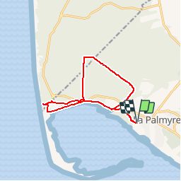
Tocht Stappen van 12,3 km beschikbaar op Nieuw-Aquitanië, Charente-Maritime, Les Mathes. Deze tocht wordt voorgesteld door marcel.F.
Beschrijving
boucle marche 12 km
pinède phare de la Coubre
Plaatsbepaling
Land:
France
Regio :
Nieuw-Aquitanië
Departement/Provincie :
Charente-Maritime
Gemeente :
Les Mathes
Locatie:
Unknown
Vertrek:(Dec)
Vertrek:(UTM)
641147 ; 5061241 (30T) N.
Opmerkingen