


j3 tarn

ARPF
Gebruiker
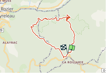

Lengte
9,6 km

Max. hoogte
903 m

Positief hoogteverschil
322 m
Km-Effort
13,8 km

Min. hoogte
677 m

Negatief hoogteverschil
318 m
Boucle
Ja
Datum van aanmaak :
2016-06-09 00:00:00.0
Laatste wijziging :
2016-06-09 00:00:00.0
5h29
Moeilijkheid : Gemakkelijk

Gratisgps-wandelapplicatie
 SityTrail
IGN / Geografische instituten
SityTrail Plus
De wereld gaat voor u open
Over ons
Tocht Stappen van 9,6 km beschikbaar op Occitanië, Aveyron, Veyreau. Deze tocht wordt voorgesteld door ARPF.
Plaatsbepaling
Land:
France
Regio :
Occitanië
Departement/Provincie :
Aveyron
Gemeente :
Veyreau
Locatie:
Unknown
Vertrek:(Dec)
Vertrek:(UTM)
519597 ; 4890994 (31T) N.
Opmerkingen