Tocht Fiets Mailly-le-Camp - de Mailly-le-camp à chelles - Photo

de Mailly-le-camp à chelles

 destras
destras

Gebruiker

© OpenStreetMap contributors
Lengte
Lengte
139 km
Max. hoogte
Max. hoogte
206 m
Positief hoogteverschil
1205 m
Km-Effort
Km-Effort  
156 km
Min. hoogte
Min. hoogte
41 m
Negatief hoogteverschil
1280 m
Boucle
Boucle
Neen
Datum van aanmaak :
2016-06-24 00:00:00.0
Laatste wijziging :
2016-06-24 00:00:00.0

(0 Bericht)

Fiets
Fiets
6h40
Moeilijkheid : Medium

Scan deze QR-code om de tocht te openen in de SityTrail-applicatie

Gratisgps-wandelapplicatie

Logo SityTrail SityTrail

IGN / Geografische instituten

SityTrail uit de App Store downloaden SityTrail uit Google Play downloaden

Logo SityTrail SityTrail World

De wereld gaat voor u open

SityTrail uit de App Store downloaden SityTrail uit Google Play downloaden SityTrail op Huawei AppGallery downloaden

Over ons

Tocht Fiets van 139 km beschikbaar op Grand Est, Aube, Mailly-le-Camp. Deze tocht wordt voorgesteld door destras.

Beschrijving

de Mailly-le-camp à chelles

Hoogteprofiel

Foto's

Plaatsbepaling

Land:
France
Regio :
Grand Est
Departement/Provincie :
Aube
Gemeente :
Mailly-le-Camp
Locatie:
Unknown
Vertrek:(Dec)
Vertrek:(UTM)
587694 ; 5391984 (31U) N.

Wandeltochten in de omgeving

Tocht Fiets Mailly-le-Camp - La Plaine Champenoise - Mailly le Camp - Photo
Fiets
tracegps

Fiets

Medium
Mailly-le-Camp, Grand Est, Aube, France
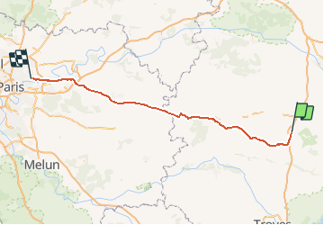
66 km | 71 km-effort
2h 30min
Ja


Sluiten
Mijn abonnementen