


cime cacia 06

barney06
Gebruiker
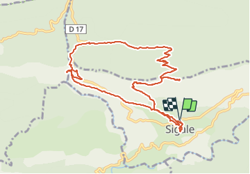

Lengte
13,2 km

Max. hoogte
1087 m

Positief hoogteverschil
731 m
Km-Effort
23 km

Min. hoogte
566 m

Negatief hoogteverschil
731 m
Boucle
Ja
Datum van aanmaak :
2016-10-23 00:00:00.0
Laatste wijziging :
2016-10-23 00:00:00.0
7h28
Moeilijkheid : Medium

Gratisgps-wandelapplicatie
 SityTrail
IGN / Geografische instituten
SityTrail Plus
De wereld gaat voor u open
Over ons
Tocht Stappen van 13,2 km beschikbaar op Provence-Alpes-Côte d'Azur, Alpes-Maritimes, Sigale. Deze tocht wordt voorgesteld door barney06.
Beschrijving
marche
Plaatsbepaling
Land:
France
Regio :
Provence-Alpes-Côte d'Azur
Departement/Provincie :
Alpes-Maritimes
Gemeente :
Sigale
Locatie:
Unknown
Vertrek:(Dec)
Vertrek:(UTM)
336432 ; 4859786 (32T) N.
Opmerkingen