


les jumeaux de Sumène - Ranc de Banes

vertygo
Gebruiker
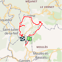

Lengte
14,1 km

Max. hoogte
695 m

Positief hoogteverschil
851 m
Km-Effort
25 km

Min. hoogte
169 m

Negatief hoogteverschil
852 m
Boucle
Ja
Datum van aanmaak :
2017-03-21 00:00:00.0
Laatste wijziging :
2017-03-21 00:00:00.0
5h13
Moeilijkheid : Medium

Gratisgps-wandelapplicatie
 SityTrail
IGN / Geografische instituten
SityTrail Plus
De wereld gaat voor u open
Over ons
Tocht Stappen van 14,1 km beschikbaar op Occitanië, Hérault, Ganges. Deze tocht wordt voorgesteld door vertygo.
Beschrijving
voir des photos sur www.vertygo.org
https://goo.gl/photos/DYtoTCZicttCJ2u38
Plaatsbepaling
Land:
France
Regio :
Occitanië
Departement/Provincie :
Hérault
Gemeente :
Ganges
Locatie:
Unknown
Vertrek:(Dec)
Vertrek:(UTM)
556899 ; 4866794 (31T) N.
Opmerkingen